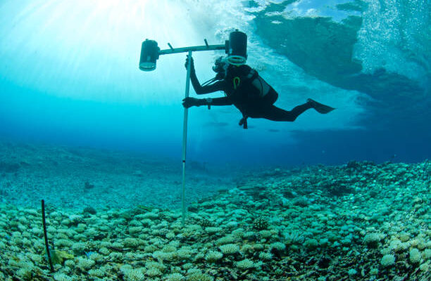
An ROV underwater survey in Vancouver, BC uses a remotely operated vehicle to capture video, sonar, and structural data below the waterline. It is used for bridge footings, dam intakes, reservoir floors, port infrastructure, and pipelines without putting a diver in the water. Deliverables typically include HD video footage, multibeam sonar imagery, and a condition report.
Most infrastructure managers assume they need a diver any time something needs to be checked underwater. That assumption costs time, money, and in some environments it creates real safety exposure that simply does not need to exist.
The problem is that a lot of the subsea work happening across British Columbia sits in conditions that make diver entry either impractical or genuinely hazardous. Cold water, low visibility, turbulent flows near dam intakes, confined piping inside reservoirs, contaminated silt in industrial sites. None of that disappears just because an inspection is overdue.
That is where ROV underwater survey Vancouver BC services fill a real gap. A remotely operated vehicle reaches places a diver cannot, carries sensors a diver cannot hold, and produces data that is fully documented and repeatable without ever requiring a person to enter the water.
What Is an ROV Underwater Survey and How Does It Work?
An ROV, or remotely operated vehicle, is a tethered robotic platform controlled from the surface. The operator watches a live feed, pilots the vehicle through the inspection zone, and the system records everything in real time. Depending on the ROV class and the sensors onboard, a single deployment can capture HD video, multibeam sonar imaging, cathodic protection readings, and even dimensional measurements.
The tether carries both power and the data signal, which means there is no latency issue and no risk of losing the vehicle. Operators in Vancouver and throughout British Columbia typically deploy ROVs from a small workboat, a dock, or directly off the structure being inspected.
Observation-Class vs. Work-Class ROVs
Observation-class vehicles are the most common choice for inspection work. They are compact, easily transported, and capable of capturing high-resolution imagery in depths commonly encountered at municipal water infrastructure, port terminals, and river crossings throughout BC. Work-class ROVs are heavier platforms used for offshore oil and gas environments or situations that require the vehicle to interact with the structure physically, such as placing sensors or cutting lines.
For most dam inspection, reservoir survey, bridge footing assessment, and pipeline condition work in the Vancouver area, an observation-class system with multibeam sonar and HD video is the right tool.
What Sensors Come Standard on an Inspection ROV?
The core payload on most inspection ROVs used in BC includes an HD pan-and-tilt camera, integrated LED lighting for zero-visibility conditions, and a depth/heading sensor package for position logging. From there, operators add mission-specific sensors: multibeam imaging sonar for mapping surfaces where camera visibility fails, cathodic protection probes for steel structures, and laser scaling systems that let analysts pull real measurements from video footage after the fact.
Here’s the thing most people miss: the camera is not always the most useful deliverable. In turbid Fraser River water or a sediment-heavy reservoir, the sonar data tells you far more about structural condition than any video feed can.
Where ROV Surveys Are Used Across British Columbia
The range of applications is wider than most clients initially expect. ROV inspection work in BC runs across municipal, industrial, energy, and marine sectors, and the conditions driving demand vary significantly by site type.
Dam Intakes and Reservoir Infrastructure
BC Hydro facilities, municipal water utilities, and irrigation districts across British Columbia rely on ROV surveys to inspect intake structures, trash screens, gate seals, and reservoir floors without taking a system offline or sending a diver into a confined, pressurized environment. Concrete condition assessments, joint mapping, and silt accumulation surveys are all standard deliverables from these projects.
Dam and intake inspection work is particularly time-sensitive in the spring freshet period, when flows are high and visibility is worst. ROV systems with forward-scanning sonar can operate in conditions where a diver simply cannot function.
Port Facilities and Marine Terminals
Vancouver’s port infrastructure, from the terminals at Roberts Bank to the marine facilities along the North Shore, requires regular inspection of steel pilings, concrete wharves, mooring hardware, and subsea pipelines running to and from vessels. ROV surveys provide a non-disruptive way to carry out these assessments without interrupting port operations or requiring vessels to move.
And this is where it gets interesting. Multibeam sonar imagery collected during an ROV survey can be processed into 3D point clouds that give engineers a dimensional record of the structure at a specific point in time. That baseline makes future inspections far more informative because you are comparing measured data, not just looking at video.
Bridge Footings and River Crossings
Scour erosion around bridge footings is one of the most underdiscovered infrastructure risks in British Columbia. ROV surveys equipped with sub-bottom profiling or multibeam bathymetry tools can map sediment conditions around footings and identify voids or erosion channels that would be completely invisible from above the waterline. Major crossings on the Fraser River, the Capilano River system, and coastal inlets throughout the province are candidates for this type of work.
ROV Survey vs. Commercial Diver Inspection: When Does Each Make Sense?
This is the question procurement teams and engineers ask most often, and the honest answer is that the two methods are complementary rather than competing.
A diver brings tactile capability. They can feel a crack, tap on concrete to test for delamination, and reach into confined spaces that an ROV cannot navigate. Non-destructive testing methods like magnetic particle inspection, ultrasonic thickness gauging, and visual weld examination all require a diver unless the structure has been purpose-built for robotic access.
An ROV brings reach, endurance, and documentation. It can survey a structure that spans hundreds of metres in a single deployment, collect quantitative sonar data rather than subjective observations, and do all of this in conditions where diver entry would require a standby decompression chamber or simply would not be authorized under WorkSafeBC regulations. For initial condition screening, large-area surveys, and any site where diver safety cannot be fully managed, ROV inspection is often the right starting point.
That sounds obvious, but most clients do not initially frame it this way. The practical pattern on complex projects is an ROV survey first to characterize what is there, followed by targeted diver inspection at the specific locations the ROV data flagged for closer attention.
Deliverables: What You Actually Receive from an ROV Underwater Survey
The output from a well-executed ROV inspection is not a USB drive of raw footage. It is a structured condition report, and the quality of that report is what determines whether the data is actually useful for engineering decisions or capital planning.
Standard deliverables from ROV surveys conducted in Vancouver and across British Columbia include edited HD video with time-coded anomaly callouts, multibeam sonar imagery and bathymetric point cloud data where applicable, GPS-positioned still photographs of defects or areas of interest, a written condition assessment with severity ratings referenced to recognized standards, and project metadata including depth logs, heading data, and environmental conditions at time of survey.
On reservoir and dam inspection projects, that package often also includes 3D photogrammetric models generated from overlapping camera frames, which give engineers a navigable visual record of the structure rather than a linear video to scrub through.
Regulatory Context for Underwater Inspections in BC
WorkSafeBC Part 24 governs commercial diving operations in British Columbia, and the standards it sets for saturation diving, surface supply diving, and mixed gas operations are among the most rigorous in North America. ROV surveys do not fall under the same regulatory framework because no diver enters the water, which in some environments simplifies mobilization significantly.
For potable water infrastructure, inspections must comply with AWWA C652-19 protocols to maintain safe water certifications. Dam inspections in BC are typically guided by the BC Dam Safety Regulation under the Water Sustainability Act, which specifies inspection frequency and reporting requirements for regulated structures. ROV surveys are increasingly accepted as the primary inspection method for these environments when diver entry would require dewatering or poses unacceptable risk.
This matters more than most clients realize. Understanding which standard your asset falls under before specifying an inspection method determines the scope, the reporting format, and the qualifications required of the inspection team.
Frequently Asked Questions
What is an ROV underwater survey?
An ROV underwater survey is an inspection carried out by a remotely operated vehicle tethered to a surface operator. The ROV collects video, sonar, and sensor data from below the waterline and transmits it in real time. The operator pilots the vehicle along the structure or across the survey area while the system logs position, depth, and all sensor outputs simultaneously.
How does an ROV survey differ from a sonar survey?
A sonar survey uses acoustic signals to build a map of a surface or seafloor without necessarily placing a vehicle near the structure. An ROV survey typically integrates sonar as one sensor among several, combining it with visual inspection and direct proximity to the target. Many ROV surveys include multibeam imaging sonar as part of the payload, so the line between the two approaches has narrowed considerably in recent years.
What is the difference between an observation ROV and a work-class ROV?
An observation ROV is designed primarily to look and record. It is compact, lightweight, and optimized for inspection tasks. A work-class ROV is larger, more powerful, and equipped to physically interact with underwater structures, such as operating valves, cutting cables, or placing sensors. Most inspection projects in British Columbia use observation-class systems unless the task requires physical intervention.
Who typically orders ROV underwater surveys in BC?
Municipal utilities ordering reservoir and dam intake inspections make up a significant portion of ROV survey work in British Columbia. Engineering firms conducting condition assessments for infrastructure owners, port authorities maintaining marine terminal assets, oil and gas operators inspecting subsea pipelines, and hydroelectric companies assessing dam structures are all common clients. First Nations communities with water infrastructure in remote areas of BC have also increasingly turned to ROV inspection because it eliminates the need to bring a large diving crew to remote sites.
How do I choose an ROV survey provider in Vancouver or BC?
Look for a provider with documented experience on the asset type you need inspected, not just general ROV capability. A firm that has inspected dam intakes in BC understands WorkSafeBC confined space protocols and the AWWA reporting standards that come with potable water entry. Ask for sample reports, not just sample footage. The report is the deliverable. Also confirm that the team operates their own ROV equipment rather than chartering it, since direct ownership usually correlates with deeper operational knowledge and faster mobilization when conditions are time-sensitive.


Comments